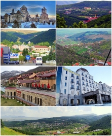
Tsaghkadzor
Wednesday, March 9, 2022
Tsaghkadzor is a spa town and urban municipal community, as well as one of the most popular health resorts in Armenia, located north of the capital Yerevan in the Kotayk Province.
According to the 2011 census, the town has a population of 1,256, down from 3,350 reported in the 1989 census. Currently, the town has an approximate population of 900 as per the 2016 official estimate.
Tsaghkadzor literally means valley of flowers or flower canyon in Armenian. The name of Tsaghkadzor is associated with the name of the nearby Tsaghkunyats Mountains, located to the west of the town.
Originally, it was known as Tsaghkunyats Dzor (Ծաղկունյաց ձոր) by its foundation during the 3rd century. In the 11th century, the town was known as Kecharuyk, or Kecharis, derived from the Kecharis Principality under the Armenian Pahlavuni family. Later, during the 17th century, the town was called Darachichak, keeping the name until 1947, when it was renamed Tsaghkadzor.
Ancient history and Middle Ages
Historically, the territory of modern-day Tsaghkadzor is associated with the Varazhnunik canton of Ayrarat province of Ancient Armenia.
Tsaghkadzor was first mentioned as Tsaghkunyats Dzor during the 3rd century when it was formed as a small settlement and quickly became the most favourite hunting ground for the Arsacid kings of Armenia. During the 4th and 5th centuries, Tsaghkunyats Dzor along the surrounding lands and forests was placed under the governance of the Varazhnuni noble family by the Arsacid kings. Later between the 5th and 7th centuries, the region was granted to the Kamsarakan and Amatuni families, under the Persian rule. Between the 7th and 9th centuries, Armenia suffered from the Arab Islamic occupation.
In the 9th century, Tsaghkunyats Dzor became part of the Bagratid Kingdom of Armenia established in 885. Starting from the 10th century, the houses of Kamsarakan and Pahlavuni—both related with the Arsacid dynasty by origins—were merged and governed the cantons of Aragatsotn, Kotayk and Varazhnunik. Prince Grigor Magistros of the Pahlavuni family became the head of the Kecharis Principality and built the Kecharis Monastery in 1033, in honor of Gregory the Illuminator. In 1051, he also built the Surp Nshan Church (Holy Sign Church). During this period, the town was known as Kecharuyk.
In the mid-11th century, the region suffered from the Seljuk invasion led by Tughril and later by his successor Alp Arslan. However, with the establishment of the Zakarid Principality of Armenia in 1201 under the Georgian protectorate, Kecharuyk witnessed a significant rise in the economic and cultural life under the rule of the Khaghbakyan and later by the Proshyan noble families, during the 13th and the 14th centuries. After the Mongols captured Ani in 1236, Armenia turned into a Mongol protectorate as part of the Ilkhanate, and the Zakarids became vassals to the Mongols. After the fall of the Ilkhanate in the mid-14th century, the Zakarid princes ruled over Lori, Shirak, Kotayk, and Ararat plain until 1360 when they fell to the invading Turkic tribes.
16th to 19th centuries
At the beginning of the 16th century, Kecharuyk became part of the Erivan Beglarbegi within the Safavid Persia. The town of Kecharuyk became known as Darachichak under the Persian rule. During the first half of the 18th century, Darachichak became part of the Erivan Khanate under the rule of the Afsharid dynasty and later under the Qajar dynasty of Persia. It remained under the Persian rule until 1827–28, when Eastern Armenia was ceded by the Russian Empire as a result of the Russo-Persian War of 1826–28 and the signing of the Treaty of Turkmenchay.
Modern history
With the fall of the Russian Empire and after the decisive Armenian victory over the Turks in the battles of Sardarabad, Abaran, and Gharakilisa, the entire region of Kotayk became part of the independent Armenia in May 1918.
After 2 years of brief independence, Armenia became part of the Soviet Union in December 1920. In 1930, Darachichak was included in the newly formed Akhta raion (later renamed Hrazdan raion in 1959). In 1947 the village of Darachichak was renamed Tsaghkadzor. In 1958, it was incorporated into an urban-type settlement.
During the Soviet era, Tsaghkadzor has been developed as a major spa town and health resort, intending to attract a large number of tourists. Many monumental buildings and dachas previously built by the wealthy merchants of Yerevan and Tiflis, were either nationalized in favour of the state or sold in auctions. In 1958, it was given the status of an urban-type settlement. In 1959, it became part of the Hrazdan raion. Later in 1984, Tsaghkadzor was given the status of a town.
After the independence of Armenia, Tsaghkadzor entered a new era of redevelopment starting from 2000. With the foundation of many luxurious hotels and sanatoriums, the town became a major winter resort attracting a large number of ski and snowboard enthusiasts from all over the world, to become one of the most developed touristic destinations in Armenia.
On 11 August 2008, around 90 American Peace Corps volunteers, trainees and staff members were relocated to Tsaghkadzor from the Republic of Georgia as a precaution during the military conflict with Russia.
Geography
Tsaghkadzor is located 50 kilometers north of the capital Yerevan and 3 kilometers east of the provincial centre Hrazdan. Surrounded with alpine meadows, the town is situated on the southeastern slope of Mount Teghenis, at a height of 1841 meters above sea level. Tsaghkadzor is surrounded by the Tsaghkunyats mountain range from the west, and the town of Hrazdan from the east.
Summers in Tsaghkadzor are characterized with mild climate, while winters are cold and snowy.


