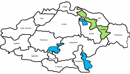
Artsakh (historic province)
Wednesday, September 20, 2023
Artsakh was the tenth province (nahang) of the Kingdom of Armenia from 189 BC until 387 AD and afterwards made part of the Caucasian Albanian satrapy of Sasanid Persia from 387 to the 7th century following the Peace of Acilisene. From the 7th to 9th centuries, it fell under Arab control. In 821, it formed the Armenian principality of Khachen and around the year 1000 was proclaimed the Kingdom of Artsakh, one of the last medieval eastern Armenian kingdoms and principalities to maintain its autonomy following the Turkic invasions of the 11th to 14th centuries.
According to Armenian and Western specialists, inscriptions dating to the Urartian period mention the region under a variety of names: "Ardakh", "Urdekhe", and "Atakhuni." In speaking about Armenia in his Geography, the classical historian Strabo refers to an Armenian region which he calls "Orchistene", which again is believed to be a Greek version of the old name of Artsakh.
According to another hypothesis put forth by David M. Lang, the ancient name of Artsakh possibly derives from the name of King Artaxias I of Armenia (190–159 BC), founder of the Artaxiad Dynasty and the kingdom of Greater Armenia.
Others also say that the name comes from Ara the Handsome. Arai Tsakh which translates to Ara's Forest.
Folk etymology holds that the name is derived from "Ar" (Aran) and "tsakh" (woods, garden) (i.e., the gardens of Aran Sisakean, the first nakharar of northeastern Armenia).
Artsakh covered the north-eastern range of the Armenian Plateau and was mostly mountainous and forested. In medieval Armenian sources it is described as a strategic and fortified region. It was bordered by the following Armenian principalities: Utik to the east, Gardman to the northeast, and Syunik to the southwest. The river Arax formed the southern boundary. The Kingdom of Artsakh (1000–1261) also included Gardman, Sodk and some other parts of Gegharkunik (in particular the southeastern shore of Lake Sevan). Its area is estimated to have been 11,528 km2.
In the Middle Ages, the neighboring Syunik region (also known as Sisakan, after the town of Sisian) sometimes lent its name to Artsakh, which would sometimes be referred to as "Little Syunik" or "Second Syunik.
Important places (mostly fortified towns) included Parisos, Tigranakert, Sodk, Tsar, Vaykunik, Asteghblur, Goroz and Berdaglukh. The fortress of Tigranakert, which was first excavated in 2005, is believed to have been founded by King Tigranes the Great of Armenia in the 1st century BC, although conceivably it could also have been founded by King Tigranes I (123–55 BC). Later, in the Caucasian Albanian period, the village of Gyutakan (Armenian: Գյուտական, known as the "Royal Village") became of great importance as the residence of Vachagan III the Pious (467–510 AD), the last King of Caucasian Albania. During early medieval times, the castle of Khachen served for a considerable time as the center of Artsakh.
According to anonymous 7th century Armenian "Geography" (Ashkharatsoyts) Artsakh comprised 12 cantons (gavars):
- Myus Haband
- Sisakan-i-Kotak
- Vaykunik
- Berdadzor
- Mets Arank
- Mets Kvenk
- Harchlank
- Mukhank
- Piank
- Parzkank
- Sisakan Vostan
- Kust-i-Parnes
- Koght


